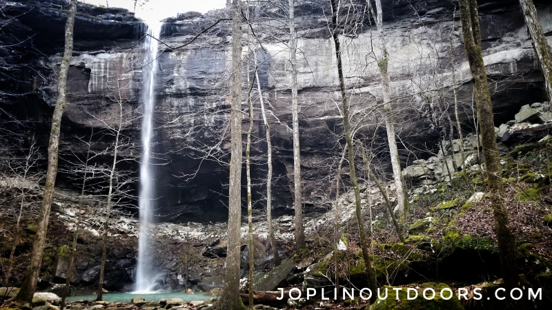
Sweden Creek Falls Natural Area is near Kingston, Arkansas. This section of 136 acres is owned and cared for by the Arkansas Natural Heritage Commission. It was added in 1977 with an old home still standing on the property from that time period. With only a 1.5 mile round trip to the top of the falls, this upper trail is well maintained and is easy to hike. However, the lower trail is harder with uneven paths and having to climb over large rocks.

You start your hike from a very small parking area only able to hold 3 or 4 vehicles. From here you will follow an old road down the hill with old ponds and farm posts. About 0.3 miles down you’ll come across an older house with a detached garage. The house is cool to explore as the basement has running water from a spring coming through the wall. Following the trail back downhill you’ll start to see and hear running water to your right. This is another cool spot to stop and explore as it has a few small falls. Here is where the trail splits with a path taking you to the top and the lower taking you to the base of the falls. This lower path is rough with wet rocks and uneven ground. Once at the base of the falls, you’ll find a beautiful valley covered in ferns and lush vegetation.

If you choose to take the top trail to your left at the split, you’ll be taken across some glades with large rocks. You will eventually be led to the top of the falls. Here you’ll see some cool rock formations from the creek running over the rocks to the falls. Be careful at the ledge and the slick rocks near the creek itself.
The hike back is always a little harder as you now have to work your way back uphill to the parking area. Taking your time to enjoy the woodlands and spotting some old fence posts makes the trip back enjoyable.

Overall this hike was lots of fun and would be great for most families who enjoy a little more of a challenge than your common hike in a city park. Just be aware of the ledges on the top trail and uneven path on the lower section.


